Difference between revisions of "MGRMap1"
| Line 2: | Line 2: | ||
[http://masonicgenealogy.com/MediaWiki/images/MGR/Map1NW.jpg http://masonicgenealogy.com/MediaWiki/images/MGR/Map1NWSm.jpg] | [http://masonicgenealogy.com/MediaWiki/images/MGR/Map1NW.jpg http://masonicgenealogy.com/MediaWiki/images/MGR/Map1NWSm.jpg] | ||
</p> | </p> | ||
| + | |||
| + | === GEOGRAPHY === | ||
| + | |||
| + | West of Barkstone and including the area around Pebblebrook, the land is very hilly and heavily forested. Pebblebrook lies in a valley, and has an extensive stone quarry. Barkstone itself is more or less the edge of the wilderness. | ||
| + | |||
| + | Elmwood and Whitepine are located on flatter land; there is a stream that flows between them, with a well-maintained footbridge built of Pebblebrook stone that crosses it; this stream goes underground south of Whitepine and is fed by the underground stream in Shaleburrow - and the cavern it traverses is wide and high enough to be navigated; it is possible to (relatively secretly) use a boat to travel all the way to the coast. The land south of these towns rises to a rocky ridge; Thistledown is near the top of that ridge. Lockhaven and Ivydale are lower in elevation, as is Shaleburrow. | ||
| + | |||
| + | Dawnrock is a very small settlement, probably not much bigger than Calogero. | ||
* ''[http://masonicgenealogy.com/MediaWiki/index.php?title=MGR_Barkstone Barkstone]'' | * ''[http://masonicgenealogy.com/MediaWiki/index.php?title=MGR_Barkstone Barkstone]'' | ||
| + | ** 3 days to Elmwood, through thick forests | ||
| + | ** 3-4 days to Ivydale, with few geographical obstacles | ||
| + | ** 3 days to Pebblebrook, over hills | ||
| + | ** 3 days to Shaleburrow, along a narrow climbing path, some of which is on an exposed ridge | ||
* [http://masonicgenealogy.com/MediaWiki/index.php?title=MGR_Dawnrock Dawnrock] | * [http://masonicgenealogy.com/MediaWiki/index.php?title=MGR_Dawnrock Dawnrock] | ||
| + | ** 2 days to Thistledown, downhill to the coast | ||
| + | ** 2 days to Whitepine, through light woods | ||
* [http://masonicgenealogy.com/MediaWiki/index.php?title=MGR_Elmwood Elmwood] | * [http://masonicgenealogy.com/MediaWiki/index.php?title=MGR_Elmwood Elmwood] | ||
| + | ** 3 days to Barkstone, through thick forests | ||
| + | ** 2 days to Whitepine, through thick forests crossing a stream on a stone bridge | ||
| + | ** 3 days to Lockhaven, on the north slope of an east-west ridge | ||
| + | ** 3 days to Shaleburrow, up the east-west ridge on a winding path | ||
* ''[http://masonicgenealogy.com/MediaWiki/index.php?title=MGR_Ivydale Ivydale]'' | * ''[http://masonicgenealogy.com/MediaWiki/index.php?title=MGR_Ivydale Ivydale]'' | ||
| + | ** 3-4 days to Barkstone, with few geographical obstacles | ||
| + | ** 1 day to Lockhaven along a well-traveled road | ||
| + | ** 2 days to Shaleburrow along a well-traveled road | ||
* ''[http://masonicgenealogy.com/MediaWiki/index.php?title=MGR_Lockhaven LOCKHAVEN]'' | * ''[http://masonicgenealogy.com/MediaWiki/index.php?title=MGR_Lockhaven LOCKHAVEN]'' | ||
| + | ** 3 days to Elmwood, on the north slope of an east-west ridge | ||
| + | ** 1 day to Ivydale along a well-traveled road | ||
| + | ** 3 days to Shaleburrow, along the southern flank of an east-west ridge | ||
| + | ** 2 days to Thistledown, up a gentle ridge | ||
* [http://masonicgenealogy.com/MediaWiki/index.php?title=MGR_Pebblebrook Pebblebrook] | * [http://masonicgenealogy.com/MediaWiki/index.php?title=MGR_Pebblebrook Pebblebrook] | ||
| + | ** 3 days to Barkstone, over hills | ||
* ''[http://masonicgenealogy.com/MediaWiki/index.php?title=MGR_Shaleburrow Shaleburrow]'' | * ''[http://masonicgenealogy.com/MediaWiki/index.php?title=MGR_Shaleburrow Shaleburrow]'' | ||
| + | ** 3 days to Barkstone, along a narrow descending path, some of which is on an exposed ridge | ||
| + | ** 3 days to Elmwood, down the east-west ridge on a winding path | ||
| + | ** 2 days to Ivydale along a well-traveled road | ||
| + | ** 3 days to Lockhaven, along the southern flank of an east-west ridge | ||
| + | ** 3-4 days to Thistledown, a difficult climb across a ridge | ||
* [http://masonicgenealogy.com/MediaWiki/index.php?title=MGR_Thistledown Thistledown] | * [http://masonicgenealogy.com/MediaWiki/index.php?title=MGR_Thistledown Thistledown] | ||
| + | ** 2 days to Dawnrock, uphill to an east-west ridge | ||
| + | ** 2 days to Lockhaven, up a gentle ridge | ||
| + | ** 3-4 days to Shaleburrow, a difficult climb across a ridge | ||
* [http://masonicgenealogy.com/MediaWiki/index.php?title=MGR_Whitepine Whitepine] | * [http://masonicgenealogy.com/MediaWiki/index.php?title=MGR_Whitepine Whitepine] | ||
| + | ** 2 days to Dawnrock, through light woods | ||
| + | ** 2 days to Elmwood, through thick forests crossing a stream on a stone bridge | ||
<hr> | <hr> | ||
Revision as of 22:34, 7 January 2017
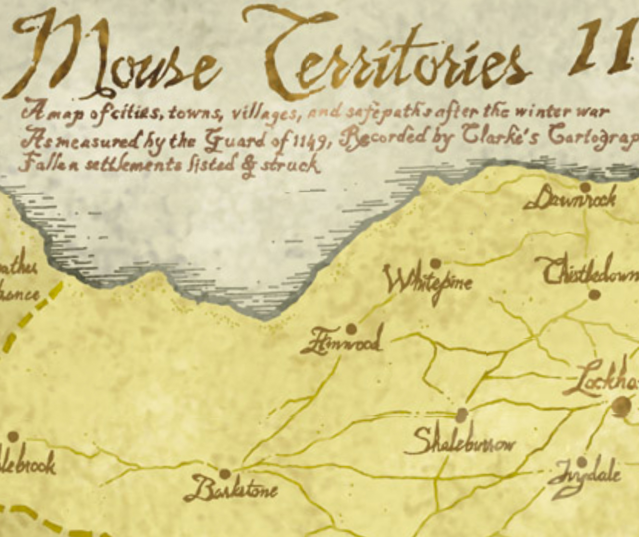
GEOGRAPHY
West of Barkstone and including the area around Pebblebrook, the land is very hilly and heavily forested. Pebblebrook lies in a valley, and has an extensive stone quarry. Barkstone itself is more or less the edge of the wilderness.
Elmwood and Whitepine are located on flatter land; there is a stream that flows between them, with a well-maintained footbridge built of Pebblebrook stone that crosses it; this stream goes underground south of Whitepine and is fed by the underground stream in Shaleburrow - and the cavern it traverses is wide and high enough to be navigated; it is possible to (relatively secretly) use a boat to travel all the way to the coast. The land south of these towns rises to a rocky ridge; Thistledown is near the top of that ridge. Lockhaven and Ivydale are lower in elevation, as is Shaleburrow.
Dawnrock is a very small settlement, probably not much bigger than Calogero.
- Barkstone
- 3 days to Elmwood, through thick forests
- 3-4 days to Ivydale, with few geographical obstacles
- 3 days to Pebblebrook, over hills
- 3 days to Shaleburrow, along a narrow climbing path, some of which is on an exposed ridge
- Dawnrock
- 2 days to Thistledown, downhill to the coast
- 2 days to Whitepine, through light woods
- Elmwood
- 3 days to Barkstone, through thick forests
- 2 days to Whitepine, through thick forests crossing a stream on a stone bridge
- 3 days to Lockhaven, on the north slope of an east-west ridge
- 3 days to Shaleburrow, up the east-west ridge on a winding path
- Ivydale
- 3-4 days to Barkstone, with few geographical obstacles
- 1 day to Lockhaven along a well-traveled road
- 2 days to Shaleburrow along a well-traveled road
- LOCKHAVEN
- 3 days to Elmwood, on the north slope of an east-west ridge
- 1 day to Ivydale along a well-traveled road
- 3 days to Shaleburrow, along the southern flank of an east-west ridge
- 2 days to Thistledown, up a gentle ridge
- Pebblebrook
- 3 days to Barkstone, over hills
- Shaleburrow
- 3 days to Barkstone, along a narrow descending path, some of which is on an exposed ridge
- 3 days to Elmwood, down the east-west ridge on a winding path
- 2 days to Ivydale along a well-traveled road
- 3 days to Lockhaven, along the southern flank of an east-west ridge
- 3-4 days to Thistledown, a difficult climb across a ridge
- Thistledown
- 2 days to Dawnrock, uphill to an east-west ridge
- 2 days to Lockhaven, up a gentle ridge
- 3-4 days to Shaleburrow, a difficult climb across a ridge
- Whitepine
- 2 days to Dawnrock, through light woods
- 2 days to Elmwood, through thick forests crossing a stream on a stone bridge